Trail Road bike La Ciotat - la Ciotat la cadière st cyr - Photo
 jlnessy
jlnessy

User

© OpenStreetMap contributors
Length
Length
32 km
Max alt
Max alt
176 m
Uphill gradient
Uphill gradient
457 m
Km-Effort
Km-Effort  
39 km
Min alt
Min alt
0 m
Downhill gradient
Downhill gradient
457 m
Boucle
Boucle
Yes
Creation date :
2023-03-05 08:40:54.636
Updated on :
2023-03-05 14:23:51.449

(1 Reviews)

Road bike
Road bike
5h40
Difficulty : Medium

Scan this QR Code to open this trail in the SityTrail application

FREE GPS app for hiking

Logo SityTrail SityTrail

IGN / Geographical institutes

Download SityTrail from the App Store Download SityTrail from Google Play

Logo SityTrail SityTrail World

The world is yours!

Download SityTrail from the App Store Download SityTrail from Google Play Download SityTrail on Huawei AppGallery

About

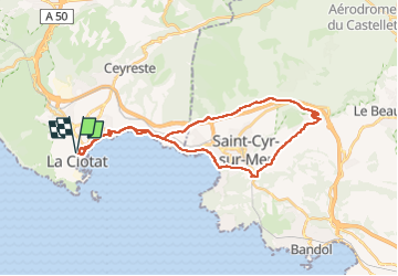
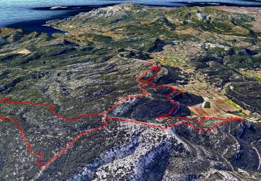
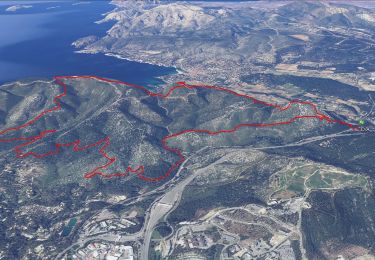
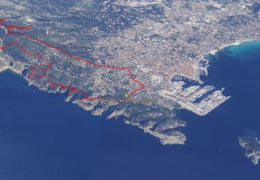
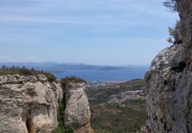
Trail Road bike of 32 km to be discovered at Provence-Alpes-Côte d'Azur, Bouches-du-Rhône, La Ciotat. This trail is proposed by jlnessy.

Description

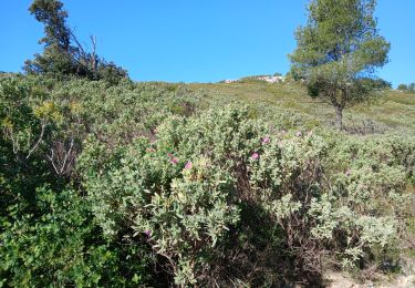
tour vélo par les petites routes. des belles petites montées et descentes avec pique nique à la Cadière   32 km

Elevation profile

Positioning

Country:
France
Region :
Provence-Alpes-Côte d'Azur
Department/Province :
Bouches-du-Rhône
Municipality :
La Ciotat
Location:
Unknown
Start:(UTM)
711869 ; 4784068 (31T) N.

Comments

Please log in to post a review or rate the element


Trails nearby

Trail Walking Ceyreste - Autour du Montounier 2eme version - Photo
Walking
GUIDE
affinetataille

Walking

Medium
(1)
Ceyreste, Provence-Alpes-Côte d'Azur, Bouches-du-Rhône, France
15.7 km | 24 km-effort
6h 0min
Yes
Trail Walking Cassis - SityTrail - cassis la couronne - Photo
Walking
GUIDE
affinetataille

Walking

Medium
(3)
Cassis, Provence-Alpes-Côte d'Azur, Bouches-du-Rhône, France
16.1 km | 24 km-effort
6h 0min
Yes
Trail Walking La Ciotat - Rando Ciotat - Photo
Walking
GUIDE
affinetataille

Walking

Difficult
(1)
La Ciotat, Provence-Alpes-Côte d'Azur, Bouches-du-Rhône, France
12.1 km | 19.9 km-effort
7h 30min
Yes
Trail Walking La Ciotat - la ciotat - Photo
Walking
Berrangerannick

Walking

Very easy
(1)
La Ciotat, Provence-Alpes-Côte d'Azur, Bouches-du-Rhône, France
6.2 km | 9.3 km-effort
3h 21min
Yes
Trail Walking La Ciotat - Balade La Ciotat  - Photo
Walking
BADEY

Walking

Difficult
(1)
La Ciotat, Provence-Alpes-Côte d'Azur, Bouches-du-Rhône, France
8.8 km | 14 km-effort
3h 7min
Yes
Trail Walking La Ciotat - Cap Canaille - Photo
Walking
DanielROLLET

Walking

Medium
(1)
La Ciotat, Provence-Alpes-Côte d'Azur, Bouches-du-Rhône, France
10.2 km | 16.2 km-effort
4h 0min
Yes
Trail Walking Ceyreste - Ceyreste/Montounier - Photo
Walking
vincent13

Walking

Medium
(1)
Ceyreste, Provence-Alpes-Côte d'Azur, Bouches-du-Rhône, France
8.9 km | 14 km-effort
2h 54min
Yes
Trail Mountain bike Ceyreste - ceyreste - Photo
Mountain bike
cro

Mountain bike

Medium
(1)
Ceyreste, Provence-Alpes-Côte d'Azur, Bouches-du-Rhône, France
19.2 km | 28 km-effort
2h 0min
Yes
Trail On foot Cassis - Couronne de Charlemagne-10-04-24 - Photo
On foot
Christiancordin

On foot

Difficult
Cassis, Provence-Alpes-Côte d'Azur, Bouches-du-Rhône, France
24 km | 36 km-effort
7h 0min
Yes


Close
My subscriptions